
Digital Compass Altimeter 8 in 1
3.4Editor score
8 in 1 functions
Low cost option
Digital compass included
Backlit display
Handheld altimeters are essential tools for anyone venturing into the outdoors. Whether you are hiking, climbing, or flying, knowing your elevation helps ensure safety and navigation accuracy. A good device provides reliable readings in varying weather conditions.
We compared ten top-rated models based on accuracy, durability, and extra features like barometers and compasses. Our selection includes analog battery-free options and advanced digital units with GPS capabilities. Each product was evaluated for real-world usability.
Each pick highlights specific strengths to help you choose the right tool for your needs. Note that availability and pricing can change frequently on retailer sites. Always check the latest details before making your final purchase decision.
3.4Editor score
4.3Editor score

4.6Editor score
As an Amazon Associate we earn from qualifying purchases.
The following table provides a side-by-side look at the key specifications for all ten models reviewed in this guide. Use this to quickly compare features and capabilities.


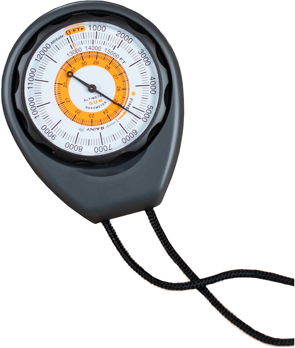
The Sun Company Altimeter 203 stands out as a reliable analog tool for outdoor enthusiasts. It holds a solid rating from users who value simplicity and durability. This device removes the need for batteries by using barometric pressure changes.
We may earn a commission when you buy through this link, at no additional cost to you.
Its rugged ABS case protects the internal mechanism from drops and impacts during hiking or camping. The adjustable dial allows you to calibrate readings based on local weather systems for accuracy. A lanyard is included for easy portability.
While effective, it only measures up to 15,000 feet which may limit high altitude use. The analog nature requires manual adjustment if pressure changes occur over time. However, these trade-offs are acceptable for basic navigation needs.
Buy this if you need a dependable backup instrument without electronic complexity. It pairs well with a compass for a traditional navigation setup. It is ideal for hikers who prefer analog tools over digital gadgets.
The battery-free design ensures you never face a dead screen when you need altitude data most.
Built with rugged ABS plastic and a lanyard, it withstands the physical demands of backpacking and climbing.
We may earn a commission when you buy through this link, at no additional cost to you.
The BTMETER BT-100WM is a versatile digital tool that goes beyond simple altitude tracking. It captures wind speed, temperature, and humidity alongside pressure and elevation. This makes it excellent for detailed weather monitoring.
We may earn a commission when you buy through this link, at no additional cost to you.
Its data logging feature allows you to store up to 16 groups of readings for later analysis. The backlit LCD screen ensures visibility in low light conditions. Users appreciate the trip hole for mounting on a tripod.
However, measuring wind speed accurately requires exposing the unit to airflow which can be tricky handheld. You must also manage battery replacements unlike analog models. The unit auto shuts off to conserve power effectively.
Consider this device if you need detailed environmental data for shooting or drone flying. It offers a lot of functionality for the price. It is a practical choice for field work and weather testing.
Store up to 16 groups of data to compare trends in temperature, humidity, and pressure over time.
Beyond altitude, it measures wind speed and chill, making it a complete handheld weather station for outdoors.
We may earn a commission when you buy through this link, at no additional cost to you.
This Digital Compass Altimeter offers a wide array of features at a budget-friendly price. It combines an altimeter, barometer, compass, and thermometer into one small device. It is designed for basic hiking and outdoor tracking.
We may earn a commission when you buy through this link, at no additional cost to you.
It measures altitude from -2300 to 29500 feet providing a broad range for most climbs. The electronic compass gives direction in eight steps to help with orientation. A backlight keeps the display readable for five seconds.
Reviewers note that while the features are numerous the accuracy is not as precise as premium units. The build feels lightweight and may not survive heavy abuse. However for occasional use it provides good value.
Choose this if you need a basic all-in-one tool without spending much money. It is suitable for casual hikers who want elevation and direction data. It serves well as a backup or training tool.
Get time, temperature, compass, and altitude readings all in a single compact device for easy carrying.
At a low cost, it provides essential outdoor metrics for users who want to try digital altimetry.
We may earn a commission when you buy through this link, at no additional cost to you.
This model mirrors the 8 in 1 utility of other budget units with a focus on hiking. It tracks elevation, temperature, and barometric pressure reliably for standard trails. It is a good alternative for casual outdoor use.
We may earn a commission when you buy through this link, at no additional cost to you.
The altitude range extends up to 29500 feet covering most mountaineering needs. The electronic compass provides direction to keep you on track. It also features weather updates to help you anticipate changes.
Users report that the sensors may need frequent calibration for consistent results. Battery life depends on how often you use the backlight. The casing is compact enough to fit easily in a jacket pocket.
Pick this if you want a feature-rich digital tool for general hiking. It balances cost and functionality well. It is best suited for users who need basic metrics and occasional direction checks.
Monitor your elevation changes and weather conditions with a single device designed for active trails.
Small enough to carry everywhere, it ensures you have essential data available during your outdoor activities.
We may earn a commission when you buy through this link, at no additional cost to you.
The Sun Company AltiLINQ is designed specifically for tracking altitude in vehicles or on trails. It mounts easily to your dashboard using hook-and-loop attachments for secure placement. It operates without batteries using analog pressure sensing.
We may earn a commission when you buy through this link, at no additional cost to you.
Its scale measures up to 15000 feet which covers most road trips and hiking routes. The weather trend indicator helps you anticipate storms based on pressure shifts. You can remove it to take on the trail easily.
While reliable for vehicle use it may not be precise enough for high altitude climbing. The analog dial requires periodic adjustment to match local pressure conditions. However this adds to the simplicity of use.
Buy this for road trips or camping vehicles to monitor elevation changes safely. It serves as a great companion for off-roading. It is ideal for drivers who want a traditional look and feel.
Secure it to your car dashboard or take it handheld on the trail with included attachments.
Without batteries to drain, this model ensures you can check your altitude whenever you need it.
We may earn a commission when you buy through this link, at no additional cost to you.
This Handheld Clinometer is a specialized tool for measuring height and slope in field work. It uses a sighting lens to provide precise readings of elevation changes. The body is made from sturdy aluminum alloy.
We may earn a commission when you buy through this link, at no additional cost to you.
It is waterproof and shockproof which ensures durability in harsh environments. The deflection angle lens makes it quick to read measurements while standing. It comes with a thick nylon carry bag for protection.
While it excels at professional tasks it may lack the automated features of digital units. You must manually look through the lens to take readings which requires practice. This design prioritizes accuracy over convenience.
Choose this if you need reliable measurements for forestry or construction projects. It is a robust tool that withstands daily wear. It is best for professionals who value precision and durability.
Use the sighting lens to measure tree heights and building slopes with professional precision.
The waterproof and shockproof design ensures it works reliably in rain and rough outdoor conditions.
We may earn a commission when you buy through this link, at no additional cost to you.
The Garmin GPSMAP 65s is a premium handheld that combines GPS and barometric data for high accuracy. It features multi-band technology to improve positioning in forests and canyons. The color display shows mapping details clearly.
We may earn a commission when you buy through this link, at no additional cost to you.
You can view elevation changes via both GPS and barometric sensors for reliability. It includes TopoActive mapping for US public lands to assist with route planning. The Explore app integration helps manage your tracks.
Its advanced features come with a higher cost compared to basic altimeters. The device is heavier than simple pocket tools which may add weight. However these trade-offs are necessary for professional navigation.
Select this if you need top-tier navigation for serious expeditions. It provides unmatched accuracy and mapping tools. It is the best choice for adventurers who demand professional-grade performance.
Expanded satellite systems ensure you get accurate GPS data even in challenging terrain.
Access federal public land maps and routes directly on the device for seamless navigation.
We may earn a commission when you buy through this link, at no additional cost to you.
This Carabiner Altimeter offers a unique design that attaches easily to your backpack. It combines an altimeter, barometer, and thermometer into a compact unit. It is rated highly by users for its convenience.
We may earn a commission when you buy through this link, at no additional cost to you.
The built-in barometric sensor predicts weather for the next 24 hours to aid planning. You can clip it onto your gear or mount it on a car dash. It uses strong ABS materials to withstand impacts.
While the display is small it provides essential readings quickly. Some users find the weather forecast useful for trip planning. The carabiner design makes it very convenient for hiking.
Buy this if you need a hands-free tool that stays on your pack. It is a great gift for outdoor enthusiasts. It works well for short hikes and casual camping.
The integrated carabiner hook lets you attach the device directly to your backpack straps easily.
Predict upcoming weather conditions up to 24 hours in advance to plan your day safely.
We may earn a commission when you buy through this link, at no additional cost to you.
This Pocket Altimeter is a compact tool designed for measuring height and slope angles. It is made from durable aluminum alloy that resists water and shocks. It is ideal for travel and exploration.
We may earn a commission when you buy through this link, at no additional cost to you.
The deflection angle lens helps you read measurements quickly. It fits easily in a pocket and comes with a soft protective case. The dial is clear and easy to read during use.
While it is sturdy it lacks digital features like automatic records. You must manually interpret the angles which takes practice. It is a simple tool for quick checks.
Choose this if you need a lightweight device for measuring angles on the go. It is suitable for architects and travelers. It provides reliable basic measurements without electronics.
The waterproof and shockproof aluminum alloy ensures the unit lasts through rough handling.
Use the high-definition azimuth plate to read angles quickly for accurate height measurements.
We may earn a commission when you buy through this link, at no additional cost to you.
The SUNROAD GPS Digital combines GPS tracking with altitude and weather features. It supports multiple satellite systems for accurate positioning. The error margin is low making it reliable for tracking.
We may earn a commission when you buy through this link, at no additional cost to you.
It includes a rechargeable battery that charges via USB for convenience. The built-in LED flashlight adds utility for emergency lighting. A backlight keeps the screen visible at night.
Users note that the menu system can be complex to navigate initially. Battery life depends on usage patterns and GPS settings. However the GPS integration offers precise location data.
Select this if you want GPS coordinates alongside your altitude data. It is a good multi-tool for sports and hiking. It is best for users who want tracking capabilities.
Three satellite systems ensure precise location tracking even in remote areas.
The built-in LED flashlight and backlight keep you visible in dark conditions.
We may earn a commission when you buy through this link, at no additional cost to you.
Choosing the right altimeter depends on your specific outdoor activities and technical needs.
Decide between analog battery-free models and digital ones that require batteries or rechargeables. Analog models never run out of power but lack extra features.
Digital units offer more data but need battery management. For long trips ensure you have spare batteries.
Check the maximum altitude the device measures to ensure it suits your hiking or climbing location. Many budget models cap at 15,000 feet.
For high elevation peaks select a unit that supports ranges up to 29,000 feet or more for full coverage.
Barometric sensors provide precise elevation data but need calibration. GPS models are accurate without calibration but consume more power.
Look for devices with multi-band support if you need high precision in dense forests or urban canyons.
Choose models with waterproof and shockproof designs to withstand drops and rain. Aluminum or rugged ABS cases are preferred for outdoor use.
A sturdy build ensures the device survives accidental drops during active adventures and daily use.
Ensure the screen is visible in sunlight and has a backlight for low light conditions. Digital screens vary widely in brightness.
Analog dials are simple to read but lack backlighting. Prioritize a clear display for safety.
Consider extra tools like compasses, thermometers, or barometers for a complete weather station. Multi-function devices save space in your pack.
Select the features that match your needs so you do not pay for unused capabilities.
Look for units that can clip to a backpack or mount on a car dashboard. A carabiner or lanyard adds portability.
Secure mounting options ensure the device is accessible without slowing down your pace.
Calibrate your analog altimeter before starting by setting it to a known elevation or local weather pressure. For digital units follow the manufacturer's guide to sync with GPS data.
Keep the display and sensors clean from dirt and moisture after every use. If your device has a waterproof rating still rinse it with fresh water if exposed to salt.
Store the device in a dry place away from extreme temperatures to protect the internal electronics. Regular checks of batteries will prevent unexpected failures in the field.
An analog altimeter uses a sealed chamber that expands and contracts with changes in air pressure. As you go higher the pressure drops and the dial moves to show elevation. It does not need batteries.
Yes digital altimeters often require calibration to match local pressure data for accurate readings. Some models auto-calibrate using GPS data which helps maintain precision in the field.
Many handheld altimeters can be mounted in vehicles to track elevation changes while driving. Models designed for car use often have mounts or clips to secure them to the dash.
Inaccurate readings often come from changes in atmospheric pressure due to weather rather than elevation. Ensure you recalibrate the device frequently or use a GPS-enabled model.
GPS altitude uses satellite signals to estimate height while barometric uses air pressure for higher accuracy. Barometric sensors react to weather changes while GPS is independent of pressure.
Yes waterproof models protect against rain and accidental spills which are common on trails. A waterproof build ensures longevity and reliability during exposure to the elements.
We reviewed ten top models ranging from simple analog tools to advanced GPS units. Each offers unique benefits depending on your need for features and accuracy.
Prioritize accuracy and battery life if you plan to use the device for long expeditions. Simpler models are often more reliable for casual hiking trips.
Always check the latest availability and pricing before buying as these factors change over time. We hope this guide helps you select the perfect altimeter for your adventures.